- WEATHER
Australia
- National
- New South Wales
- Victoria
- Queensland
- Western Australia
- South Australia
- Tasmania
- ACT
- Northern Territory
Long Range Forecasts
- WARNINGS
- RADAR
- SATELLITE
- MAPS & CHARTS
- LONG RANGE
Long Range Forecasts
- CLIMATE
Climate Indicators
- NEWS
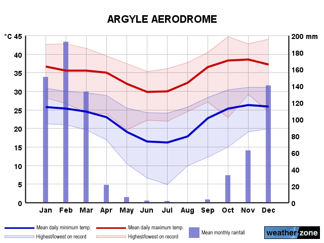
Argyle Aerodrome Long-term Averages
| Jan | Feb | Mar | Apr | May | Jun | Jul | Aug | Sep | Oct | Nov | Dec | Ann | |
|---|---|---|---|---|---|---|---|---|---|---|---|---|---|
| Mean Max (°C) |
36.5 | 35.9 | 35.8 | 35.3 | 32.1 | 29.7 | 29.9 | 32.3 | 36.6 | 38.7 | 38.8 | 37.5 | 34.9 |
| Mean Min (°C) |
25.8 | 25.3 | 24.9 | 23.1 | 19.1 | 16.4 | 15.9 | 17.5 | 22.4 | 25.3 | 26.2 | 26.1 | 22.3 |
| Mean Rain (mm) |
164.5 | 190.5 | 148.8 | 25.7 | 7.4 | 3.9 | 2.9 | 0.3 | 2.4 | 33.2 | 66.4 | 138.0 | 753.0 |
| Median Rain (mm) |
159.2 | 154.0 | 67.2 | 7.8 | 0.0 | 0.0 | 0.0 | 0.0 | 0.0 | 14.2 | 44.6 | 105.3 | 715.4 |
| Mean Rain Days |
14.6 | 13.7 | 10.0 | 2.9 | 1.1 | 0.7 | 0.4 | 0.2 | 0.7 | 3.8 | 7.8 | 12.2 | 66.0 |
Argyle Aerodrome Daily Records
| Jan | Feb | Mar | Apr | May | Jun | Jul | Aug | Sep | Oct | Nov | Dec | Ann | |
|---|---|---|---|---|---|---|---|---|---|---|---|---|---|
| High Max (°C) |
44.2 | 42.9 | 42.1 | 41.5 | 38.0 | 39.1 | 37.0 | 39.2 | 42.1 | 44.7 | 45.2 | 45.5 | 45.5 |
| Low Max (°C) |
26.3 | 26.6 | 24.2 | 23.4 | 19.2 | 15.2 | 16.9 | 20.9 | 27.0 | 22.9 | 29.1 | 24.5 | 15.2 |
| High Min (°C) |
31.9 | 30.5 | 30.4 | 31.1 | 27.1 | 25.0 | 24.2 | 26.0 | 29.3 | 31.2 | 31.9 | 33.2 | 33.2 |
| Low Min (°C) |
21.2 | 20.1 | 19.6 | 14.3 | 9.9 | 6.6 | 4.8 | 9.8 | 12.2 | 15.0 | 18.8 | 19.9 | 4.8 |
| High Rain (mm) |
138.2 | 108.2 | 208.8 | 72.4 | 38.4 | 29.6 | 54.0 | 5.0 | 14.2 | 78.0 | 56.6 | 83.4 | 208.8 |
Argyle Aerodrome Monthly Records
| Jan | Feb | Mar | Apr | May | Jun | Jul | Aug | Sep | Oct | Nov | Dec | Ann | |
|---|---|---|---|---|---|---|---|---|---|---|---|---|---|
| High Mn. Max (°C) |
39.0 | 38.5 | 39.1 | 38.1 | 34.4 | 32.9 | 32.3 | 34.8 | 38.2 | 40.9 | 41.1 | 41.9 | 36.4 |
| Low Mn. Max (°C) |
33.5 | 32.9 | 32.2 | 31.0 | 28.8 | 25.3 | 28.2 | 29.8 | 34.5 | 35.1 | 35.6 | 35.5 | 32.8 |
| High Mn. Min (°C) |
27.4 | 26.9 | 26.9 | 25.3 | 22.7 | 20.5 | 19.7 | 19.8 | 25.1 | 27.0 | 27.6 | 28.7 | 24.0 |
| Low Mn. Min (°C) |
24.3 | 23.9 | 23.4 | 20.2 | 15.4 | 12.4 | 13.1 | 15.3 | 19.7 | 23.5 | 24.4 | 24.9 | 20.7 |
| High Rain (mm) |
320.0 | 420.0 | 734.5 | 142.2 | 102.6 | 65.6 | 65.0 | 5.4 | 24.4 | 151.0 | 221.4 | 321.2 | 1762.4 |
| Low Rain (mm) |
29.5 | 32.0 | 5.2 | 0.0 | 0.0 | 0.0 | 0.0 | 0.0 | 0.0 | 0.0 | 5.0 | 18.8 | 352.5 |
Argyle Aerodrome Annual Temperatures & Rainfall
Argyle Aerodrome Average Number of Days With Temperatures
| Jan | Feb | Mar | Apr | May | Jun | Jul | Aug | Sep | Oct | Nov | Dec | Ann | |
|---|---|---|---|---|---|---|---|---|---|---|---|---|---|
| ≥ 40°C |
4.1 | 2.6 | 1.4 | 0.3 | 0.0 | 0.0 | 0.0 | 0.0 | 1.5 | 9.7 | 11.1 | 7.3 | 38.7 |
| ≥ 35°C |
21.4 | 17.1 | 20.4 | 17.3 | 4.9 | 0.6 | 0.5 | 4.8 | 23.4 | 27.9 | 26.3 | 24.3 | 189.1 |
| ≥ 30°C |
29.7 | 26.8 | 29.2 | 28.3 | 23.5 | 14.8 | 16.4 | 24.4 | 28.8 | 30.2 | 28.8 | 29.5 | 310.7 |
| ≤ 2°C |
0.0 | 0.0 | 0.0 | 0.0 | 0.0 | 0.0 | 0.0 | 0.0 | 0.0 | 0.0 | 0.0 | 0.0 | 0.0 |
| ≤ 0°C |
0.0 | 0.0 | 0.0 | 0.0 | 0.0 | 0.0 | 0.0 | 0.0 | 0.0 | 0.0 | 0.0 | 0.0 | 0.0 |
Argyle Aerodrome 'per Week' Values (14th/86th Percentiles)
| Jan | Feb | Mar | Apr | May | Jun | Jul | Aug | Sep | Oct | Nov | Dec | Ann | |
|---|---|---|---|---|---|---|---|---|---|---|---|---|---|
| High Max |
39.8 | 39.2 | 37.9 | 37.4 | 34.8 | 32.6 | 32.5 | 34.7 | 38.6 | 40.7 | 41.3 | 40.6 | 39.2 |
| Low Max |
32.9 | 32.5 | 32.4 | 33.2 | 28.8 | 25.9 | 26.6 | 29.0 | 34.0 | 35.6 | 36.4 | 33.7 | 29.8 |
| High Min |
27.6 | 27.1 | 26.2 | 25.7 | 22.6 | 20.0 | 19.8 | 21.2 | 25.3 | 27.7 | 28.5 | 28.1 | 26.9 |
| Low Min |
23.6 | 23.5 | 22.9 | 20.3 | 15.6 | 12.0 | 12.0 | 13.9 | 19.0 | 22.5 | 23.7 | 23.3 | 16.0 |
Argyle Aerodrome Data Availability
| Jan | Feb | Mar | Apr | May | Jun | Jul | Aug | Sep | Oct | Nov | Dec | Ann | |
|---|---|---|---|---|---|---|---|---|---|---|---|---|---|
| Years of Minima |
30 | 30 | 30 | 29 | 29 | 30 | 29 | 30 | 30 | 30 | 30 | 29 | 29.0 |
| Earliest Entry |
1995 | 1995 | 1995 | 1995 | 1995 | 1994 | 1994 | 1994 | 1994 | 1994 | 1994 | 1994 | 1994 |
| Latest Entry |
2024 | 2024 | 2024 | 2024 | 2023 | 2023 | 2023 | 2023 | 2023 | 2023 | 2023 | 2023 | 2024 |
| Years of Maxima |
30 | 30 | 30 | 29 | 29 | 30 | 30 | 30 | 30 | 30 | 30 | 29 | 29.0 |
| Earliest Entry |
1995 | 1995 | 1995 | 1995 | 1995 | 1994 | 1994 | 1994 | 1994 | 1994 | 1994 | 1994 | 1994 |
| Latest Entry |
2024 | 2024 | 2024 | 2024 | 2023 | 2023 | 2023 | 2023 | 2023 | 2023 | 2023 | 2023 | 2024 |
| Years of Rainfall |
38 | 38 | 39 | 37 | 38 | 38 | 39 | 39 | 39 | 38 | 37 | 37 | 39.0 |
| Earliest Entry |
1985 | 1985 | 1985 | 1985 | 1985 | 1985 | 1985 | 1985 | 1985 | 1985 | 1985 | 1985 | 1985 |
| Latest Entry |
2024 | 2024 | 2024 | 2024 | 2023 | 2023 | 2023 | 2023 | 2023 | 2023 | 2023 | 2023 | 2024 |
Station Details
ARGYLE AERODROME
Kimberley, Western Australia
Kimberley, Western Australia
16.6380°S 128.4516°E
164m AMSL
Commenced 1986
Commenced 1986
Enter a postcode or town name for local weather, or text to search the site. » advanced search
Rainfall to soak some parched areas of WA
13:00 AEST Rain could finally fall over parts of southwestern WA over the next week, wetting areas that have barely seen any rain for months. This rainfall will be caused by a low pressure trough extending from the Kimberley down to southwestern WA from late Thursday, with a low pressure system developing within it early to mid-next week. The images below shows that widespread rainfall of between 15 to 30mm is forecast in the week across western and southern WA, with isolated falls of between 40 to 60mm in the Gascoyne and Goldfields districts. Image: Accumulated rainfall to 8pm AWST on Thursday, May 2, according to Access (top) and ECMWF (bottom) You can see there is still some uncertainty about where and how much rainfall will fall in these areas late this week and early next week, with one model placing rain over Perth and the other predicting it will completely miss the city altogether. The heaviest rainfall days are likely to be Friday and mid next week when the low pressure system develops.
- 10:33 AEST Tassie snow, Melbourne temps go low
- 16:40 AEST Australia's tropical cyclone season coming to an end
- 10:07 AEST Wind returning to southeastern Australia
- 16:32 AEST Anzac Day dawn service weather around Australia