- WEATHER
Australia
- National
- New South Wales
- Victoria
- Queensland
- Western Australia
- South Australia
- Tasmania
- ACT
- Northern Territory
Long Range Forecasts
- WARNINGS
- RADAR
- SATELLITE
- MAPS & CHARTS
- LONG RANGE
Long Range Forecasts
- CLIMATE
Climate Indicators
- NEWS
Marine Weather
Cape Preston to Northwest Cape Marine Weather Overview
 navigate by marine district
Perth Local
Kuri Bay to Wallal
Wallal to Cape Preston
Cape Preston to Northwest Cape
Northwest Cape to Carnarvon
Carnarvon to Kalbarri
Kalbarri to Jurien Bay
Perth Offshore
Mandurah to Cape Leeuwin
Cape Leeuwin to Bremer Bay
Bremer Bay to Israelite Bay
Israelite Bay to Eucla
Kuri Bay to Wyndham
 most recent warnings
WA - Fri 22:13 WSTStrong Wind Warning for Pilbara Coast East, Pilbara Coast West & West Kimberley Coast
View all current warnings
tides for Exmouth
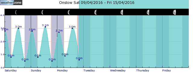
tides for Onslow
 forecast
Variable about 10 knots becoming east to southeasterly 15/20 knots before dawn then tending east to northeasterly in the middle of the day. Winds reaching up to 30 knots offshore east of Onslow in the late morning. Seas: Below 1 metre, increasing to 1/2 metres during the morning, then decreasing to 1 metre by early evening. Swell: North to northeasterly 1/1.5 metres, tending east to northeasterly around 1 metre during the morning. Outlook Sunday: East to southeasterly 15/20 knots tending east to northeasterly in the morning then becoming variable about 10 knots in the evening. Seas: Below 1 metre, increasing to 1/1.5 metres during the morning, then decreasing to 1 metre during the afternoon. Swell: West to southwesterly below 1 metre inshore, increasing to 1/1.5 metres offshore west of Barrow Island during the morning. Outlook Monday: South to southwesterly 10/15 knots tending northeast to southeasterly during the morning then becoming variable about 10 knots during the afternoon. Seas: Below 1 metre. Swell: West to southwesterly below 1 metre inshore, increasing to 1/1.5 metres offshore.
Issued Fri 22:13 WSTSeas: Up to 2.0m
Swell: Up to 1.5m, NNE
forecast winds
Saturday: E/NE 30 ktsSunday: E/SE 15/20 kts
Monday: S/SW 10/15 kts
- locations
- Barrow Island
- Mardie
- Onslow
Sun & Moon Times
| first light | sunrise | sunset | last light | moon rise | moon set | moon phase | full moon | last quarter | new moon | first quarter |
|---|---|---|---|---|---|---|---|---|---|---|
|
06:11 WST |
06:34 WST |
18:03 WST |
18:26 WST |
16:03 WST |
04:07 WST |
|
Apr 24 |
May 1 |
May 8 |
May 15 |
A very wet weekend for southeast Qld, northeast NSW
11:48 AEST A prolonged rainfall event is set to bring large totals to parts of NSW and Qld from Saturday, with possible heavy falls and flooding. A low-pressure system in the Coral Sea, a deepening coastal trough and persistent easterlies will bring moisture-laden air into southeast Qld and northeast NSW will bring days of rainfall to the region. While there is not a drop of rain on the radar over southeast Qld and Northeast NSW on Friday morning, the mass of cloud associated with a low in the Coral Sea will enhance rainfall over the weekend.
- 10:07 AEST Southerly surges across the southeast
- 13:20 AEST Generation gone with the wind
- 11:29 AEST Devilishly dry in Tasmania
- 16:41 AEST Dubai deluge: a year's rainfall in a day


