- WEATHER
Australia
- National
- New South Wales
- Victoria
- Queensland
- Western Australia
- South Australia
- Tasmania
- ACT
- Northern Territory
Long Range Forecasts
- WARNINGS
- RADAR
- SATELLITE
- MAPS & CHARTS
- LONG RANGE
Long Range Forecasts
- CLIMATE
Climate Indicators
- NEWS
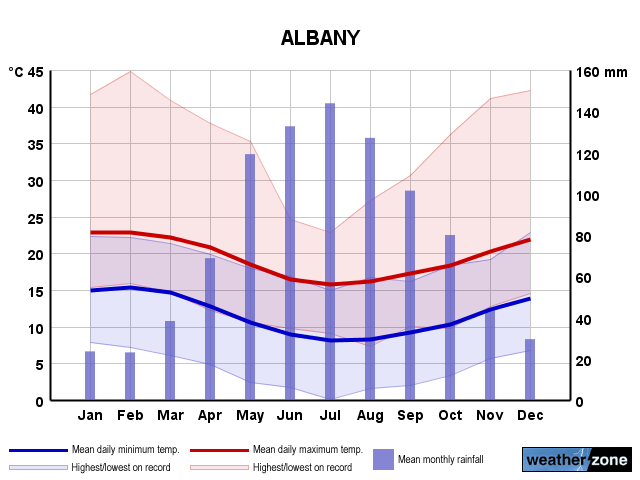
Albany Long-term Averages
| Jan | Feb | Mar | Apr | May | Jun | Jul | Aug | Sep | Oct | Nov | Dec | Ann | |
|---|---|---|---|---|---|---|---|---|---|---|---|---|---|
| Mean Max (°C) |
23.1 | 23.2 | 22.5 | 21.2 | 19.0 | 17.1 | 16.1 | 16.6 | 17.7 | 18.8 | 20.6 | 21.9 | 19.8 |
| Mean Min (°C) |
15.5 | 15.8 | 15.1 | 13.1 | 11.0 | 9.5 | 8.5 | 8.6 | 9.5 | 10.7 | 12.6 | 14.2 | 12.0 |
| Mean Rain (mm) |
25.0 | 22.6 | 39.0 | 70.7 | 113.0 | 130.4 | 146.6 | 125.4 | 101.1 | 77.7 | 48.1 | 29.9 | 929.9 |
| Median Rain (mm) |
15.4 | 15.0 | 30.3 | 63.4 | 112.2 | 122.9 | 146.1 | 116.1 | 92.7 | 72.8 | 42.3 | 22.9 | 936.2 |
| Mean Rain Days |
7.8 | 7.6 | 11.2 | 14.2 | 18.0 | 19.9 | 21.5 | 20.9 | 18.2 | 16.2 | 12.0 | 9.4 | 176.8 |
Albany Daily Records
| Jan | Feb | Mar | Apr | May | Jun | Jul | Aug | Sep | Oct | Nov | Dec | Ann | |
|---|---|---|---|---|---|---|---|---|---|---|---|---|---|
| High Max (°C) |
41.7 | 44.8 | 40.8 | 37.7 | 35.2 | 40.0 | 23.3 | 27.3 | 30.6 | 36.2 | 41.1 | 42.2 | 44.8 |
| Low Max (°C) |
15.3 | 15.9 | 14.7 | 12.2 | 10.6 | 9.7 | 9.1 | 7.3 | 7.1 | 9.7 | 12.8 | 14.5 | 7.1 |
| High Min (°C) |
22.3 | 23.5 | 21.5 | 19.9 | 17.9 | 16.9 | 15.8 | 16.7 | 16.5 | 18.4 | 20.0 | 22.8 | 23.5 |
| Low Min (°C) |
0.0 | 7.2 | 6.1 | 0.0 | 2.4 | 0.9 | 0.1 | 1.6 | 2.0 | 3.4 | 5.6 | 5.5 | 0.0 |
| High Rain (mm) |
87.6 | 58.7 | 89.7 | 80.6 | 103.6 | 72.4 | 83.8 | 81.0 | 79.8 | 46.7 | 113.6 | 59.9 | 113.6 |
Albany Monthly Records
| Jan | Feb | Mar | Apr | May | Jun | Jul | Aug | Sep | Oct | Nov | Dec | Ann | |
|---|---|---|---|---|---|---|---|---|---|---|---|---|---|
| High Mn. Max (°C) |
25.7 | 26.4 | 25.6 | 23.8 | 21.0 | 19.0 | 17.7 | 19.2 | 19.6 | 21.6 | 22.6 | 24.9 | 21.0 |
| Low Mn. Max (°C) |
20.5 | 21.3 | 19.7 | 18.5 | 16.6 | 14.7 | 14.2 | 14.7 | 15.6 | 17.0 | 18.3 | 20.0 | 18.8 |
| High Mn. Min (°C) |
17.7 | 18.0 | 17.2 | 15.7 | 13.6 | 12.0 | 9.9 | 10.9 | 11.5 | 13.1 | 15.2 | 16.1 | 13.4 |
| Low Mn. Min (°C) |
13.0 | 13.7 | 12.4 | 11.0 | 9.1 | 7.0 | 6.9 | 6.7 | 8.0 | 8.2 | 10.4 | 12.1 | 10.8 |
| High Rain (mm) |
217.0 | 161.4 | 166.0 | 233.9 | 289.4 | 295.6 | 269.3 | 267.6 | 198.5 | 189.2 | 226.1 | 95.7 | 1395.2 |
| Low Rain (mm) |
1.5 | 0.0 | 4.0 | 4.9 | 31.0 | 40.3 | 61.2 | 34.0 | 36.8 | 23.2 | 5.8 | 1.5 | 620.5 |
Albany Annual Temperatures & Rainfall
Albany Average Number of Days With Temperatures
| Jan | Feb | Mar | Apr | May | Jun | Jul | Aug | Sep | Oct | Nov | Dec | Ann | |
|---|---|---|---|---|---|---|---|---|---|---|---|---|---|
| ≥ 40°C |
0.0 | 0.0 | 0.0 | 0.0 | 0.0 | 0.0 | 0.0 | 0.0 | 0.0 | 0.0 | 0.0 | 0.0 | 0.2 |
| ≥ 35°C |
0.3 | 0.3 | 0.4 | 0.1 | 0.0 | 0.0 | 0.0 | 0.0 | 0.0 | 0.0 | 0.2 | 0.2 | 1.4 |
| ≥ 30°C |
1.1 | 1.1 | 1.3 | 0.7 | 0.0 | 0.0 | 0.0 | 0.0 | 0.0 | 0.2 | 0.5 | 0.8 | 5.8 |
| ≤ 2°C |
0.0 | 0.0 | 0.0 | 0.0 | 0.0 | 0.0 | 0.1 | 0.0 | 0.0 | 0.0 | 0.0 | 0.0 | 0.2 |
| ≤ 0°C |
0.0 | 0.0 | 0.0 | 0.0 | 0.0 | 0.0 | 0.0 | 0.0 | 0.0 | 0.0 | 0.0 | 0.0 | 0.0 |
Albany 'per Week' Values (14th/86th Percentiles)
| Jan | Feb | Mar | Apr | May | Jun | Jul | Aug | Sep | Oct | Nov | Dec | Ann | |
|---|---|---|---|---|---|---|---|---|---|---|---|---|---|
| High Max |
25.8 | 26.1 | 25.6 | 24.4 | 22.0 | 19.4 | 18.4 | 19.4 | 20.6 | 21.9 | 23.5 | 24.4 | 23.8 |
| Low Max |
20.2 | 20.2 | 19.2 | 17.8 | 15.8 | 14.4 | 13.5 | 13.7 | 14.4 | 15.6 | 17.5 | 19.0 | 15.6 |
| High Min |
17.6 | 18.0 | 17.2 | 15.4 | 13.5 | 11.7 | 10.6 | 10.6 | 11.7 | 12.9 | 14.8 | 16.2 | 15.8 |
| Low Min |
12.8 | 13.0 | 12.2 | 10.6 | 8.3 | 6.7 | 6.1 | 6.1 | 7.0 | 7.8 | 10.0 | 11.7 | 7.9 |
Albany Data Availability
| Jan | Feb | Mar | Apr | May | Jun | Jul | Aug | Sep | Oct | Nov | Dec | Ann | |
|---|---|---|---|---|---|---|---|---|---|---|---|---|---|
| Years of Minima |
79 | 81 | 81 | 78 | 78 | 78 | 79 | 80 | 80 | 81 | 81 | 79 | 80.0 |
| Earliest Entry |
1907 | 1907 | 1907 | 1907 | 1907 | 1907 | 1907 | 1907 | 1907 | 1907 | 1907 | 1907 | 1907 |
| Latest Entry |
2024 | 2024 | 2024 | 2024 | 2023 | 2023 | 2023 | 2023 | 2023 | 2023 | 2023 | 2023 | 2024 |
| Years of Maxima |
81 | 81 | 81 | 77 | 77 | 78 | 79 | 80 | 80 | 81 | 80 | 80 | 80.0 |
| Earliest Entry |
1907 | 1907 | 1907 | 1907 | 1907 | 1907 | 1907 | 1907 | 1907 | 1907 | 1907 | 1907 | 1907 |
| Latest Entry |
2024 | 2024 | 2024 | 2024 | 2023 | 2023 | 2023 | 2023 | 2023 | 2023 | 2023 | 2023 | 2024 |
| Years of Rainfall |
118 | 120 | 118 | 116 | 116 | 117 | 117 | 117 | 117 | 117 | 117 | 116 | 117.0 |
| Earliest Entry |
1907 | 1877 | 1907 | 1907 | 1907 | 1907 | 1907 | 1907 | 1907 | 1907 | 1907 | 1907 | 1877 |
| Latest Entry |
2024 | 2024 | 2024 | 2024 | 2023 | 2023 | 2023 | 2023 | 2023 | 2023 | 2023 | 2023 | 2024 |
Station Details
ALBANY
Southern Coastal, Western Australia
Southern Coastal, Western Australia
35.0289°S 117.8808°E
3m AMSL
Commenced 1877
Commenced 1877
Enter a postcode or town name for local weather, or text to search the site. » advanced search
Uncontrolled WA fire causes massive smoke plume
14:48 AEST A bushfire burning out of control in the far southwest of WA has created a 700 km-long smoke plume that can be seen from space.
- 11:52 AEST Storms hitting WA as Perth's wait for rain continues
- 14:32 AEST Satellites capture huge dust storm crossing Mediterranean Sea
- 08:00 AEST A digger's letter from snowbound Gallipoli
- 15:39 AEST Summery Sydney, wintry Melbourne