- WEATHER
Australia
- National
- New South Wales
- Victoria
- Queensland
- Western Australia
- South Australia
- Tasmania
- ACT
- Northern Territory
Long Range Forecasts
- WARNINGS
- RADAR
- SATELLITE
- MAPS & CHARTS
- LONG RANGE
Long Range Forecasts
- CLIMATE
Climate Indicators
- NEWS
Marine Weather
Fraser Is Waters Marine Weather Overview
 |
Swell height | Districts with warnings | 3pm forecast wind |
 navigate by marine district
Moreton Bay
Southeast Gulf
Northeast Gulf
Peninsula Waters
North Tropical Waters
Tropical Waters
Central Coast
Capricornia
Southeast Coast
Hervey Bay
Fraser Is Waters
Great Barrier Reef
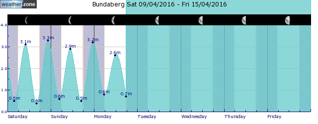
tides for Bundaberg
 forecast
Southeasterly 15/20 knots. Seas: 1.5 metres. Swell: Southerly below 1 metre inshore, increasing to around 1 metre offshore. Outlook Thursday: Southeasterly 15/20 knots. Seas: 1/1.5 metres. Swell: Southeasterly 1/1.5 metres, tending easterly 1.5 metres during the afternoon. Outlook Friday: Southeasterly 15/20 knots. Seas: Around 1 metre, increasing to 1/1.5 metres during the morning. Swell: Easterly 1/1.5 metres inshore, increasing to 1.5/2 metres offshore. Outlook Saturday: Southeasterly 15/25 knots. Seas: 1.5/2 metres. Swell: East to southeasterly 1.5 metres inshore, increasing to 1.5/2 metres offshore.
Issued Wed 15:50 ESTSeas: Up to 1.5m
Swell: Up to 1.0m, S
forecast winds
Wednesday: SE 15/20 ktsThursday: SE 15/20 kts
Friday: SE 15/20 kts
Saturday: SE 15/25 kts
- locations
- Double Is Point
- Rainbow Beach
- Maryborough
- Hervey Bay
- Bundaberg
Sun & Moon Times
| first light | sunrise | sunset | last light | moon set | moon rise | moon phase | full moon | last quarter | new moon | first quarter |
|---|---|---|---|---|---|---|---|---|---|---|
|
05:39 EST |
06:02 EST |
17:39 EST |
18:02 EST |
03:25 EST |
16:09 EST |
|
Apr 13 |
Apr 21 |
Apr 28 |
May 4 |
Equatorial Rossby wave brings increased tropical cyclone risk to northern Australia
14:28 AEST A pulse in a lesser-known tropical wave will bring increased risk of tropical cyclone activity over northern Australia in the coming week.


