- WEATHER
Australia
- National
- New South Wales
- Victoria
- Queensland
- Western Australia
- South Australia
- Tasmania
- ACT
- Northern Territory
Long Range Forecasts
- WARNINGS
- RADAR
- SATELLITE
- MAPS & CHARTS
- LONG RANGE
Long Range Forecasts
- CLIMATE
Climate Indicators
- NEWS
Marine Weather
Illawarra Marine Weather Overview
 |
Swell height | Districts with warnings | 3pm forecast wind |
 navigate by marine district
Canberra Lakes
Sydney Inshore
Byron Coast
Macquarie Coast
Hunter Waters
Sydney Offshore
Illawarra
Batemans Coast
Coffs Coast
Eden Coast
 most recent warnings
NSW/ACT - Sun 10:00 EDTGale Warning Sydney Enclosed Waters & Macquarie, Hunter, Sydney, Illawarra & Batemanss. Strong Wind Warning Coffs & Edens. Cancelled Byron
View all current warnings
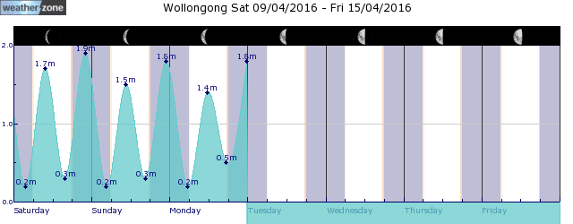
tides for Wollongong
 forecast
Southerly 30/40 knots decreasing to 25/30 knots in the late evening. Seas: 3/4 metres. Swell: Southeasterly 2.5/4 metres. Outlook Monday: Southerly 25/30 knots, reaching up to 40 knots during the day. Seas: 3/4 metres. Swell: Southeasterly 4 metres, tending southerly 4/6 metres during the morning. Outlook Tuesday: South to southwesterly 20/30 knots. Seas: 2.5/3 metres. Swell: Southerly 6/7 metres.
Issued Sun 10:00 ESTSeas: Up to 4.0m
Swell: Up to 4.0m, SE
forecast winds
Sunday: S 30/40 ktsMonday: S 40 kts
Tuesday: S/SW 20/30 kts
- locations
- Albion Park
- Port Kembla
- Campbelltown
- Nowra
- Wollongong
Sun & Moon Times
| first light | sunrise | sunset | last light | moon set | moon rise | moon phase | first quarter | full moon | last quarter | new moon |
|---|---|---|---|---|---|---|---|---|---|---|
|
06:42 EDT |
07:07 EDT |
18:55 EDT |
19:20 EDT |
19:14 EDT |
08:56 EDT |
|
Apr 5 |
Apr 13 |
Apr 21 |
Apr 28 |
Enter a postcode or town name for local weather, or text to search the site. » advanced search
Damaging winds rip through NSW coast
09:33 AEDT Residents of eastern NSW have not experienced great outdoor weather this weekend, but Saturday night turned it up a notch, as damaging winds and heavy rain pushed through coastal Sydney and Illawarra overnight into Sunday morning.


