- WEATHER
Australia
- National
- New South Wales
- Victoria
- Queensland
- Western Australia
- South Australia
- Tasmania
- ACT
- Northern Territory
Long Range Forecasts
- WARNINGS
- RADAR
- SATELLITE
- MAPS & CHARTS
- LONG RANGE
Long Range Forecasts
- CLIMATE
Climate Indicators
- NEWS
Marine Weather
Fraser Is Waters Marine Weather Overview
 |
Swell height | Districts with warnings | 3pm forecast wind |
 navigate by marine district
Moreton Bay
Southeast Gulf
Northeast Gulf
Peninsula Waters
North Tropical Waters
Tropical Waters
Central Coast
Capricornia
Southeast Coast
Hervey Bay
Fraser Is Waters
Great Barrier Reef
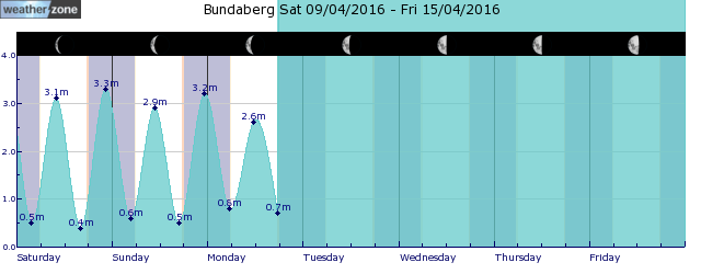
tides for Bundaberg
 forecast
Southerly 15/20 knots tending southeasterly in the morning. Seas: 1/1.5 metres. Swell: South to southeasterly around 1 metre inshore, increasing to 1/1.5 metres offshore. Outlook Saturday: Southeasterly 10/15 knots, reaching up to 20 knots offshore early in the morning. Seas: Around 1 metre, increasing to 1/1.5 metres offshore. Swell: Southeasterly 1/1.5 metres, decreasing to around 1 metre during the afternoon. Outlook Sunday: Southeasterly 10/15 knots turning easterly during the evening. Seas: Around 1 metre. Swell: East to southeasterly around 1 metre.
Issued Fri 04:45 ESTSeas: Up to 1.5m
Swell: Up to 1.5m, SSE
forecast winds
Friday: S 15/20 ktsSaturday: SE 20 kts
Sunday: SE 10/15 kts
- locations
- Double Is Point
- Rainbow Beach
- Maryborough
- Hervey Bay
- Bundaberg
Sun & Moon Times
| first light | sunrise | sunset | last light | moon rise | moon set | moon phase | first quarter | full moon | last quarter | new moon |
|---|---|---|---|---|---|---|---|---|---|---|
|
05:38 EST |
06:00 EST |
17:47 EST |
18:10 EST |
12:08 EST |
22:36 EST |
|
Apr 5 |
Apr 13 |
Apr 21 |
Apr 28 |
Clouds clear to reveal immense scale of Queensland flooding
21:01 AEDT Satellites have captured spectacular images of the massive floods currently affecting southwest Queensland, revealing water stretching thousands of kilometres across the Australian outback.


