- WEATHER
Australia
- National
- New South Wales
- Victoria
- Queensland
- Western Australia
- South Australia
- Tasmania
- ACT
- Northern Territory
Long Range Forecasts
- WARNINGS
- RADAR
- SATELLITE
- MAPS & CHARTS
- LONG RANGE
Long Range Forecasts
- CLIMATE
Climate Indicators
- NEWS
Marine Weather
Gulf Waters Marine Weather Overview
 |
Swell height | Districts with warnings | 3pm forecast wind |
 navigate by marine district
Adelaide Local Waters
Far West Coast
West Coast
Gulf Waters
South Central
South East
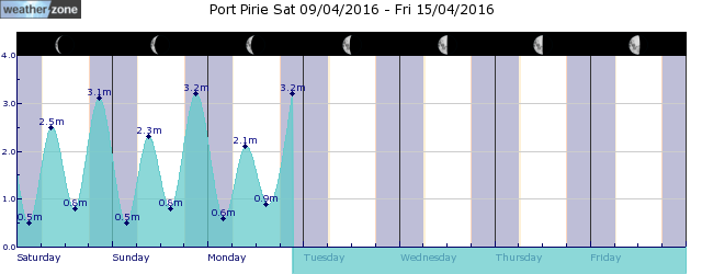
tides for Port Pirie
tides for Whyalla
tides for Eucla
 forecast
Southerly 15/20 knots, reaching up to 25 knots north of Cowell to Wallaroo in the evening. Seas: Around 1 metre, increasing to 1/2 metres by early evening. Swell: South to southwesterly below 1 metre, increasing to 1/1.5 metres south of Cowell to Wallaroo. Outlook Saturday: South to southeasterly 10/15 knots becoming variable about 10 knots in the middle of the day then becoming south to southeasterly 10/15 knots in the early afternoon. Winds reaching up to 20 knots north of Cowell to Wallaroo early in the morning and again in the evening. Seas: Around 1 metre. Swell: South to southwesterly around 1 metre, increasing to 1/2 metres south of Cowell to Wallaroo. Outlook Sunday: Variable about 10 knots becoming west to southwesterly 10/15 knots in the morning then tending south to southwesterly 15/20 knots in the early afternoon. Seas: Around 1 metre, increasing to 1/1.5 metres north of Cowell to Wallaroo during the afternoon. Swell: South to southwesterly 1/1.5 metres, increasing to 1.5/2.5 metres south of Cowell to Wallaroo. Outlook Monday: South to southwesterly 10/15 knots increasing to 20 knots before tending south to southeasterly 10/15 knots during the afternoon. Seas: Around 1 metre, increasing to 1/1.5 metres north of Cowell to Wallaroo during the afternoon or evening. Swell: South to southwesterly 1/2 metres, increasing to 2/3 metres south of Port Neill to Port Victoria.
Issued Fri 15:50 CSTSeas: Up to 2.0m
Swell: Up to 1.5m, SSW
forecast winds
Friday: S 25 ktsSaturday: S/SE 20 kts
Sunday: S/SW 15/20 kts
Monday: S/SW increasing 20 kts
- locations
- Port Lincoln
- Price
- Warooka
- Roseworthy
- Edithburgh
- Snowtown
- Minlaton
- Cleve
- Maitland
- Kadina
- Port Pirie
- Port Augusta
- Whyalla
Sun & Moon Times
| first light | sunrise | sunset | last light | moon set | moon rise | moon phase | full moon | last quarter | new moon | first quarter |
|---|---|---|---|---|---|---|---|---|---|---|
|
07:09 CDT |
07:34 CDT |
19:10 CDT |
19:35 CDT |
23:38 CDT |
15:02 CDT |
|
Apr 13 |
Apr 21 |
Apr 28 |
May 4 |
Twin cold fronts bringing snow to Tasmania this weekend
11:05 AEDT A burst of wintry weather will hit Tasmania this weekend, delivering a mix of snow, small hail, rain and blustery winds.


