- WEATHER
Australia
- National
- New South Wales
- Victoria
- Queensland
- Western Australia
- South Australia
- Tasmania
- ACT
- Northern Territory
Long Range Forecasts
- WARNINGS
- RADAR
- SATELLITE
- MAPS & CHARTS
- LONG RANGE
Long Range Forecasts
- CLIMATE
Climate Indicators
- NEWS
Marine Weather
Cape Preston to Northwest Cape Marine Weather Overview
 navigate by marine district
Perth Local
Kuri Bay to Wallal
Wallal to Cape Preston
Cape Preston to Northwest Cape
Northwest Cape to Carnarvon
Carnarvon to Kalbarri
Kalbarri to Jurien Bay
Perth Offshore
Mandurah to Cape Leeuwin
Cape Leeuwin to Bremer Bay
Bremer Bay to Israelite Bay
Israelite Bay to Eucla
Kuri Bay to Wyndham
tides for Exmouth
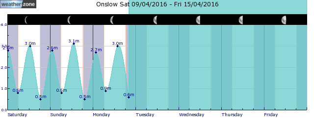
tides for Onslow
 forecast
Northwest to northeasterly 10/15 knots, reaching up to 25 knots in Exmouth Gulf in the late evening. Winds tending northwesterly in the late evening. Seas: Below 1 metre, increasing to around 1 metre west of Onslow. Swell: West to southwesterly below 1 metre inshore, increasing to 1/1.5 metres about offshore western waters. Outlook Thursday: South to southwesterly 10/15 knots tending northwest to northeasterly in the early morning then becoming variable about 10 knots in the morning. Seas: Below 1 metre, increasing to around 1 metre west of Onslow. Swell: West to southwesterly around 1 metre offshore. Outlook Friday: Variable about 10 knots. Seas: Below 0.5 metres. Swell: West to southwesterly around 1 metre offshore, increasing to 1/1.5 metres around midday. Outlook Saturday: Variable about 10 knots becoming west to northwesterly 10/15 knots during the afternoon then tending west to southwesterly during the evening. Seas: Below 1 metre. Swell: West to southwesterly 1/1.5 metres offshore.
Issued Wed 16:00 WSTSeas: Up to 1.0m
Swell: Up to 1.5m, WSW
forecast winds
Wednesday: NW/NE 25 ktsThursday: S/SW 10/15 kts
Friday: Variable 10 kts
Saturday: W/NW 10/15 kts
- locations
- Barrow Island
- Mardie
- Onslow
Sun & Moon Times
| first light | sunrise | sunset | last light | moon set | moon rise | moon phase | full moon | last quarter | new moon | first quarter |
|---|---|---|---|---|---|---|---|---|---|---|
|
06:07 WST |
06:30 WST |
18:12 WST |
18:34 WST |
04:03 WST |
16:41 WST |
|
Apr 13 |
Apr 21 |
Apr 28 |
May 4 |
Equatorial Rossby wave brings increased tropical cyclone risk to northern Australia
14:28 AEST A pulse in a lesser-known tropical wave will bring increased risk of tropical cyclone activity over northern Australia in the coming week.


