- WEATHER
Australia
- National
- New South Wales
- Victoria
- Queensland
- Western Australia
- South Australia
- Tasmania
- ACT
- Northern Territory
Long Range Forecasts
- WARNINGS
- RADAR
- SATELLITE
- MAPS & CHARTS
- LONG RANGE
Long Range Forecasts
- CLIMATE
Climate Indicators
- NEWS
Marine Weather
Wallal to Cape Preston Marine Weather Overview
 |
Swell height | Districts with warnings | 3pm forecast wind |
 navigate by marine district
Perth Local
Kuri Bay to Wallal
Wallal to Cape Preston
Cape Preston to Northwest Cape
Northwest Cape to Carnarvon
Carnarvon to Kalbarri
Kalbarri to Jurien Bay
Perth Offshore
Mandurah to Cape Leeuwin
Cape Leeuwin to Bremer Bay
Bremer Bay to Israelite Bay
Israelite Bay to Eucla
Kuri Bay to Wyndham
 most recent warnings
WA - Tue 16:00 WSTStrong Wind Warning for North Kimberley Coast. Cancellation for Pilbara Coast East, Pilbara Coast West & West Kimberley Coast
View all current warnings
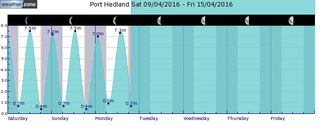
tides for Port Hedland
 forecast
East to southeasterly 15/25 knots, reaching up to 30 knots offshore west of Port Hedland in the late morning. Seas: 1.5/2.5 metres, decreasing below 1.5 metres by early evening. Swell: Easterly around 1 metre west of Port Hedland. Outlook Wednesday: Southeasterly 15/20 knots turning easterly 15/25 knots before dawn. Winds reaching up to 30 knots offshore during the morning and early afternoon. Seas: Around 1 metre, increasing to 1.5/2.5 metres during the morning, then decreasing below 1.5 metres by early evening. Swell: East to northeasterly below 1 metre inshore, increasing to 1/1.5 metres offshore during the afternoon. Outlook Thursday: Southeasterly 15/20 knots turning easterly 15/25 knots during the morning. Seas: 1/2 metres, decreasing below 1 metre during the evening. Swell: East to northeasterly below 1 metre inshore, increasing to 1/1.5 metres offshore.
Issued Tue 10:00 WSTSeas: Up to 2.5m
Swell: Up to 1.0m, E
forecast winds
Tuesday: E/SE 30 ktsWednesday: E 30 kts
Thursday: E 15/25 kts
Sun & Moon Times
| first light | sunrise | sunset | last light | moon set | moon rise | moon phase | first quarter | full moon | last quarter | new moon |
|---|---|---|---|---|---|---|---|---|---|---|
|
05:59 WST |
06:21 WST |
17:44 WST |
18:07 WST |
18:53 WST |
08:54 WST |
|
May 4 |
May 13 |
May 20 |
May 27 |
Positive SAM and warm oceans dominate Australia's winter outlook
12:20 AEST Australia's primary climate drivers are currently in a neutral phase, which means the weather around Australia is likely to be dominated by more local effects heading into winter.
- 11:28 AEST Frosty mornings ahead as large high dominates
- 12:06 AEST Wet week ahead for eastern NSW
- 11:34 AEST Mesoscale low drenches NSW Hunter, Central Coast regions
- 16:50 AEST NSW coast hit by heavy rain


