- WEATHER
Australia
- National
- New South Wales
- Victoria
- Queensland
- Western Australia
- South Australia
- Tasmania
- ACT
- Northern Territory
Long Range Forecasts
- WARNINGS
- RADAR
- SATELLITE
- MAPS & CHARTS
- LONG RANGE
Long Range Forecasts
- CLIMATE
Climate Indicators
- NEWS
Marine Weather
Byron Coast Marine Weather Overview
 navigate by marine district
Canberra Lakes
Sydney Inshore
Byron Coast
Macquarie Coast
Hunter Waters
Sydney Offshore
Illawarra
Batemans Coast
Coffs Coast
Eden Coast
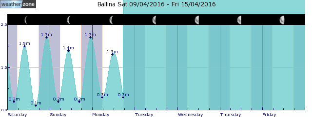
tides for Ballina
 forecast
Variable about 10 knots becoming southeasterly 10/15 knots in the late afternoon. Winds reaching up to 20 knots offshore south of Yamba in the late evening. Seas: Below 1 metre. Swell: Southeasterly 1/1.5 metres, tending southerly around 1 metre during the afternoon. Outlook Sunday: Southeasterly 10/15 knots, reaching up to 20 knots offshore south of Cape Byron early in the morning. Winds shifting north to northeasterly in the evening. Seas: Around 1 metre. Swell: Southerly around 1 metre, increasing to 1/1.5 metres around midday. Outlook Monday: North to northwesterly 10/15 knots shifting south to southeasterly during the morning. Seas: Below 1 metre. Swell: Southerly 1/1.5 metres.
Issued Sat 10:00 ESTSeas: Up to 1.0m
Swell: Up to 1.5m, SE
forecast winds
Saturday: SE 20 ktsSunday: SE 20 kts
Monday: N/NW 10/15 kts
- locations
- Yamba
- Alstonville
- Byron Bay
- Ballina
Sun & Moon Times
| first light | sunrise | sunset | last light | moon set | moon rise | moon phase | full moon | last quarter | new moon | first quarter |
|---|---|---|---|---|---|---|---|---|---|---|
|
06:34 EDT |
06:57 EDT |
18:39 EDT |
19:03 EDT |
00:23 EDT |
13:56 EST |
|
Apr 13 |
Apr 21 |
Apr 28 |
May 4 |
Twin cold fronts bringing snow to Tasmania this weekend
11:05 AEDT A burst of wintry weather will hit Tasmania this weekend, delivering a mix of snow, small hail, rain and blustery winds.


