- WEATHER
Australia
- National
- New South Wales
- Victoria
- Queensland
- Western Australia
- South Australia
- Tasmania
- ACT
- Northern Territory
Long Range Forecasts
- WARNINGS
- RADAR
- SATELLITE
- MAPS & CHARTS
- LONG RANGE
Long Range Forecasts
- CLIMATE
Climate Indicators
- NEWS
Marine Weather
Central North Marine Weather Overview
 navigate by marine district
Derwent Estuary
Hobart Waters
Inland Waters
Far Northwest
Central North
Northeast
Banks Strait
Upper East
Lower East
Southeast
Southwest
Central West
 most recent warnings
TAS - Tue 05:00 ESTStrong Wind Warning for Far North West, Lower East, South East and Central West coasts. Cancellation for Central North Coast
View all current warnings
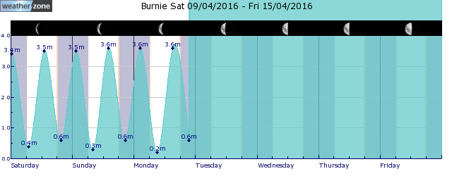
tides for Burnie
tides for Launceston
 forecast
Easterly 15/20 knots turning northeasterly 15/25 knots in the morning. Seas: 1/2 metres. Swell: Westerly below 1 metre. Outlook Wednesday: Northeasterly 15/20 knots turning easterly 10/15 knots in the late afternoon. Seas: 1/2 metres, decreasing to 1/1.5 metres during the morning, then decreasing to 1 metre during the afternoon. Swell: Northeasterly around 1 metre. Outlook Thursday: Easterly 10/15 knots turning northeasterly 15/20 knots during the day. Seas: Around 1 metre. Swell: Westerly below 1 metre.
Issued Tue 05:00 ESTSeas: Up to 2.0m
Swell: Up to 1.0m, W
forecast winds
Tuesday: NE 15/25 ktsWednesday: NE 15/20 kts
Thursday: NE 15/20 kts
- locations
- Low Head
- Bridport
- Scottsdale
- Wynyard
- Burnie
- Devonport
- Launceston
Sun & Moon Times
| first light | sunrise | sunset | last light | moon set | moon rise | moon phase | last quarter | new moon | first quarter | full moon |
|---|---|---|---|---|---|---|---|---|---|---|
|
06:19 EST |
06:46 EST |
17:48 EST |
18:15 EST |
08:48 EST |
18:30 EST |
|
Apr 21 |
Apr 28 |
May 4 |
May 13 |
Enter a postcode or town name for local weather, or text to search the site. » advanced search
Lyrid meteor shower ? how to see it from Australia
16:09 AEST The Lyrid meteor shower will be visible from Australia later this month, offering stargazers an opportunity to witness one of Earth’s oldest known meteor showers.
- 12:31 AEST Months of rain in a day in southern WA
- 16:39 AEST Boomerang Errol: tropical system could have Kimberley homecoming
- 10:39 AEST 'Pink moon' to illuminate Australia this weekend
- 13:04 AEST Tropical cyclone to form near WA


